News
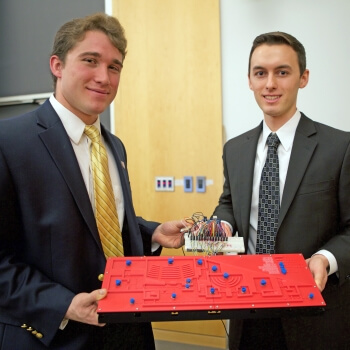
Joe Pappas (left), S.B. '17, a mechanical engineering and computer science concentrator, and Chris Carnes, S.B. '17, a mechanical engineering concentrator, display the tactical map they and their classmates developed in "Engineering Problem Solving and Design Project" (ES 96). (Photo by Adam Zewe/SEAS Communications.)
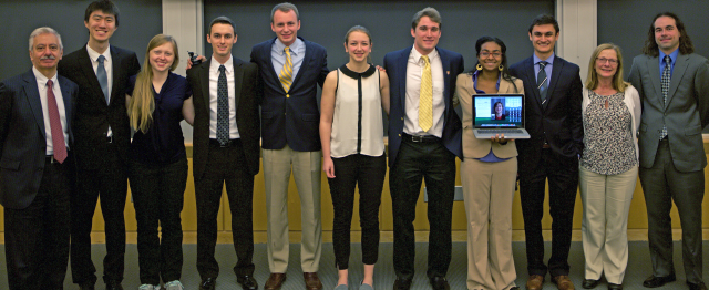
(From left) Co-instructor Fawwaz Habbal, students Starr Wen, Kira Headrick, Chris Carnes, John Holland, Jessica Ewald, Joe Pappas, Eboni White, Sylvia Rosenberg (on the computer screen), Shaan Erickson, University Disability Services Director Michele Clopper, and Co-instructor Chris Lombardo. (Photo by Adam Zewe/SEAS Communications.)
Ducking into a restroom or dropping by a water fountain on the way to class is second nature to the majority of students at the Harvard John A. Paulson School of Engineering and Applied Sciences (SEAS), who spend hours working inside the familiar surroundings of the Pierce and Maxwell-Dworkin academic buildings.
To an individual who has a visual impairment or who is wheelchair user, those simple acts of navigation can be much more challenging.
In an effort to improve accessibility on campus, students in the course “Engineering Problem Solving and Design Project” (ES 96) worked with the University Disability Services to develop tools that make navigation easier for individuals with disabilities.
The hands-on course is a critical part of the students’ learning, since it provides experience working with a client and developing feasible solutions to real-life problems, explained co-instructor Fawwaz Habbal, Executive Dean for Education and Research.
“As instructors, we don’t tell the students what to do. That is up to them,” he said. “That level of freedom is key to the learning that takes place in the course, and it is also a very transformative experience for the students.”
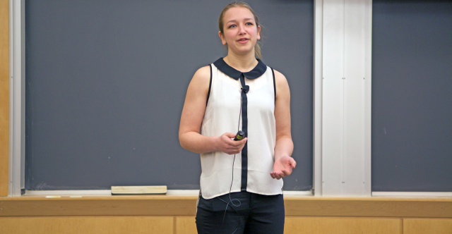
Jessica Ewald, S.B. '17, an engineering sciences concentrator, explains the team's project during their end-of-term presentation. (Photo by Adam Zewe/SEAS Communications.)
The students approached the problem by seeking a better understanding of the challenges faced by individuals with disabilities. In addition to conducting research and interviews, they visited the Perkins School for the Blind, where they learned the history of education for the blind, including tactile learning and use of acoustics to determine geographical location.
Those experiences fueled the development of two navigational tools.
Going mobile
One component of their two-part solution is an Android application, which the students created using the software program Indoo.rs, that shows users the shortest accessible route from point A to point B within and between Pierce Hall and Maxwell-Dworkin. Students developed a mobile map of the interiors of both buildings, identified points of interest, and noted features like elevators, ramps, and accessible room entrances.
The app presents a number of navigation options: users can locate themselves within the buildings, find a route to another room, or see the locations of nearby restrooms, water fountains, and emergency exits. Using a “find the nearest” function; users can also get step-by-step directions along an accessible path to a nearby point of interest. The application links Indoo.rs with Google Maps, so a user can exit one building, enter the other, and continue using the way-finding feature.
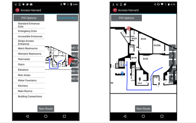
This screenshot shows the app the students developed displaying an accessible path to a point of interest.
“One of the main challenges for this team was taking a complex floor plan and simplifying it so it would be easy to read on a first glance,” said Jessica Ewald, S.B. ’17, an engineering sciences concentrator.
Touching on a tactile solution
The students also used the simplified floor plan they created to develop a 3D printed tactile map that could help an individual with a visual impairment navigate inside Maxwell-Dworkin. The map uses different elevations to show the route through the building and incorporates separate textures to identify various points of interest.
Tactile symbols are described in a legend with both braille and text, so individuals who cannot read Braille can also use the map. In addition, the map is wired to a microprocessor that enables audio feedback. Users press buttons to hear descriptions of indoor spaces.
“Our tactile map aims to enable individuals with a visual impairment to navigate through an unfamiliar building with efficiency and confidence,” said Chris Carnes, S.B. ’17, a mechanical engineering concentrator. “The inclusion of audio feedback buttons makes our map stand out from more traditional tactile maps. Our main goal was to improve the accessibility for all individuals.”
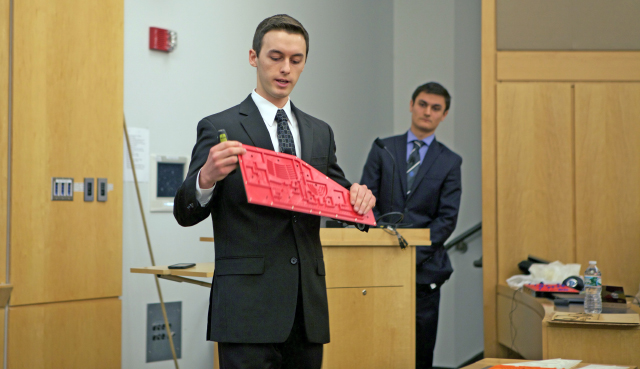
Chris Carnes, S.B. '17, a mechanical engineering concentrator, displays the tactile map he and his fellow students created. (Photo by Adam Zewe/SEAS Communications).
Co-instructor Christopher Lombardo, Assistant Director for Undergraduate Studies in Engineering, was impressed by how the students utilized resources from all around campus, and the Perkins School for the Blind, to become acquainted with the experience of having a physical disability.
“I hope that students will take this multidisciplinary experience and their experience engaging end users and experts forward into projects they will pursue in the future,” he said. “To be an effective engineer, one must be able to engage all relevant stakeholders to design products that address human needs.”
The work of the SEAS students will be helpful to others in the University community as officials explore future campus projects, said Michele Clopper, Director University Disability Services.
“I was impressed by how much the students learned within the semester,” she said. “They came into this project not knowing about accessibility and disability; in the end they did a great job identifying barriers and developing both solutions and empathy.”
Cutting-edge science delivered direct to your inbox.
Join the Harvard SEAS mailing list.
Scientist Profiles
Fawwaz Habbal
Senior Lecturer on Applied Physics
Press Contact
Adam Zewe | 617-496-5878 | azewe@seas.harvard.edu